
So wow, what a day! One of the big names for mountains to climb, and I did it three times just because the first time was so great. I did get a puncture though, saw the memorial of someone who died climbing the mountain, and more white rocks that you can shake a stick at.
The day started out quite fogging in the morning after the
huge downpours of the day before. They were so bad that the hotel I was in
flooded and the local fire brigade were kept busy all night helping people out
apparently. Just down the road 13 people died because of the flooding. Good
idea to try and not cycle through that me thinks. The lady at the hotel said it
would be fine though as it had moved on to Italy. I am unsure if serious
flooding would be any better in Italy but I assume she was more just putting my
mind at rest.

So out again through the lavender fields. Once again it was
all picked but the scent still filled the air. The fog was quite thick on the
ground but you could see bits of blue sky every now and then so I knew it would
not last long once I started up the mountain, which was only just down the
road. From Sault, the road starts climbing at a very respectable 5%. Enough to
need to push against the pedals, but also not too steep so you can keep
clicking down the 24 kilometres to the top quite quickly.
Once you are through the lavender fields and meadows not far
out of Sault, you enter a forest. It is quite dense so you can’t actually see
any views, only the occasional patch of white rock to remind you of what you
are climbing up to.

It is like this right the way up to about 7 kilometres to go
when you start to leave the forest and you suddenly are introduced to the lunar
landscape that is the top of Mont Ventoux. In the sun it just shimmers white
against beautiful blue sky. In the morning the forest was quite cool but once
you see the summit and the forest opens up, it all starts to warm up nicely.

The Sault route is the easier road up, but along the way
there were already quite a few cyclists heading up. What was just awesome to
see is that there was no single stereotype of people heading up – road bikes,
electric bikes, mountain bikes, large people, slim people, weekend warriors, professionals,
and even people who looked like they hadn’t been on a bike for a large number
of years. Was very cool to just see people out having a go at the big climb.
With six kilometres to the top you join the road up from
Bedoin at the Chalet Reynard. From here the summit and that very obvious
tower are in plain sight for the duration. Six kilometres is still a fir chunk
of distance that summit never seems to get any closer! The gradient ramps up as
well, no much at first, just to 7%. The road skirts the side of the hill along
the white rocks as you continue to climb. It was about 15 degrees at this
stage, nice and cool for climbing, but I could imagine that in the heat of
summer the reflection of the sun off the rocks must be quite debilitating!

Things start to get a bit heated though as the road comes up
further to 10% for the last two kilometres. It is not far now though and the
summit finally starts to look closer. Round you go past the first of the
paparazzi, then on past the Tom Simpson memorial where the famous British
cyclist died whilst climbing the mountain in a stage of the Tour from a
combination of over exertion and stimulants. Well I was exerted but not over
stimulated as it had been over an hour and half since my last coffee.
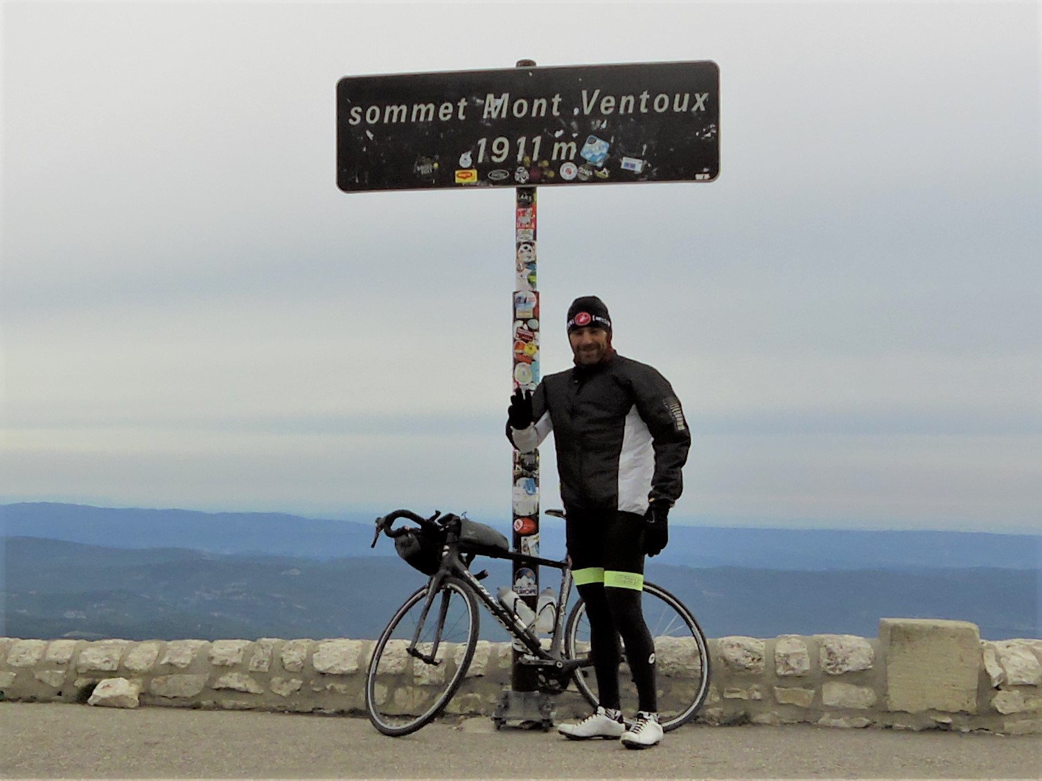
 |
| Didn't want to ruin my flow so stopped for the photo on the way down |
At the memorial it is just less than one kilometre to go to
the top. I found it easy to find but others I overheard missed it, but if you
keep looking on your right past the one kilometre to go sign you will see it.
You then pass another paparazzi and you are home and hosed, just make sure your
jersey zipper is all the way up and you have your pose ready so you can look
like a pro as you go past. Once at the top I had to get in line for the obligatory
photo at the sign, it was really that busy.

Anyway, the view from up there was really quite something. I
saw the Alps, the snow capped mountains I had just left days earlier, and the
flat land down towards the coast of Southern France. Was really awesome!

So on with some warmer clothes, and then downhill to Bedoin,
but unfortunately my downhill was interrupted. In the morning I had done the
tried and true finger pinch on my tyres to see if they needed air, and the back
one was down a little. Not enough for my hand pump to make a difference I
thought, so decided to stop at the first bike shop and borrow a pump. I never
saw one. On the way down I was doing a great job, I thought, of going around
gravel patches that the heavy rain had washed on the road, but just outside the
Chalet Reynard I heard the dreaded hissing of air rapidly escaping from somewhere.
On closer inspection my rear tyre was dead flat. So I stopped and fixed it
without hassle, but had to laugh as over six weeks of touring the first
puncture I get was a pinch caused by me not pumping up my tyres enough. Oh
well.

So once that was all fixed up I continued down to Bedoin and
found a bike shop to pump up my tyre. Second priority was a quick feed so found
a boulegerieXXXXXXX and had a flan and coffee. Flan I have found are just
amazing; custardy goodness, sweet carbs and easy for my stomach to digest it
seems. Then it was straight back up the hill.
The road was pretty much exacting in a lot of ways – you
leave town, you enter a forest, you leave the forest at six kilometres to go
and head through the white rocks for the rest. The major difference though is
that from Bedoin through the forest it is steep. 10% is the norm with little
places of respite. Some of the roads are also longish and so with no view and
straight roads it can drag a little, but it is a shorter climb, being only 21
kilometres, but also a higher elevation gain. Yep, Sault definitely was easier!

At the Chalet you get your first real respite for the climb
and it is very welcome! From Sault it was an increase and the start of the
steeper climbing, from Bedoin that same stretch of road is respite to catch
your breath before it getting back into the steeper stuff. The paparazzi were
still there so I feigned a face that showed it was easy as I passed them, but I
think the sweat dripping off my bars was probably enough to show my lies.
The cloud had started to come in now so as I got to the
summit for the second time it was a lot colder. So back in line for the photo
with the sign, can of coke and a banana and off I went down to Malaucene for
the start of the third time up.
(Photo missing)
From Malaucene the climb is quite different. You start in
town and head into forest again, like the other climbs, but the road winds its
way on the side of a hill for a lot of it so you actually get some nice views
to the towns below or across to the Alps. In that respect it was more
interesting.
It was also more interesting as the road also was changing a
bit more too. It is steep again like the road from Bedoin (10% mainly), but
after about 10 kilometres it mixes it up and you get anything from short flat
bits to steep treats again. Sometimes this can be hard to get into a rhythm
with, but on the third ascent of a mountain the short respites are glorious!
Once again there is a lovely marker at 6 kilometres to go
which is great for the soul, this time it is a roundabout where you can turn
off the main road and head for a ski field, although I guess in winter the ski
field is the main road not the summit? I must admit but the 6 kilometres to go
I was starting to count down the individual kilometres. I was in one gear
easier than what I would normally be in for those gradients, and I was
beginning to get up there based on brute force. Mind you, I still had the 32
tooth (highest gear) still to go for an emergency if I needed it.
You don’t actually see the top of the climb until with 2
kilometres to go pop around a corner and it is right in front of you. It looks
close enough to touch and only slightly higher than you so you wonder where the
2 kilometres will fit in. Well for the first time today I entered some
switchbacks, big long switchbacks that lead you up the last of it. It is only
here that you finally leave the forest and are in that desolate white rock
landscape.
 |
| Photo taken on the way down but at the 2km to go mark |
But now the wind had gotten up, freezing wind, but it wasn’t
far to the top so muscled it out. This time the paparazzi had all packed up and
left so no photos, but also there wasn’t a queue at the top for the sign photo.
I certainly didn’t hang around this time up there, the wind
was way too cold. I quickly got dressed in my warm clothes and headed straight
back down to warmth, a shower and a large meal.

So a fantastic day all round where not even a puncture could
spoil it. If I was to rate the climbs I would say that from Sault it is the
easiest and prettiest. Bedoin would be the hardest but you really appreciate
the awesome view of the lunar landscape when you leave the forest, it really is
a slap in the face when you see it. From Malaucene it is the most enjoyable I
would say, but you really miss out on the lunar part of the ride, and that is
what separates this climb out from others really and makes it special.
All up it took 7 hours of riding, 135km and 4,350m of climbing.
Loved it!
Highlight: The
first glimpse of the summit, those white rocks and that famous tower. Just an amazing sight!
Lowlight: Quite
gutted that my photos didn’t capture the climbs like I would have liked. Will
just have to do it all again to get it right eh!
Lesson Learned: May have to use a slightly more rigorous test
for tyre pressures than the pinch test.
Fabulous! Go Andrew! (and Rose of course) M.
ReplyDeleteAwesome mate. Well done on keeping the discipline to blog it all.
ReplyDelete